


You may also like
-
Antique map of Italy Poster
Institute of Liepzig · 1887 · Classic Italy map poster with crisp borders, islands, and dense geographic labeling
Poster from £9 · Framed from £16
Regular price From £6.00Regular price -
Map of Iceland Poster
Kongelige Danske Søkort-Arkiv · 1871 · Detailed nautical vintage print mapping Iceland with soundings and coastal place names
Poster from £9 · Framed from £16
Regular price From £6.00Regular price -
Eastern division of Paris Poster
James Shury · 1834 · Finely engraved Paris map poster with dense street detail and crisp black linework
Poster from £9 · Framed from £16
Regular price From £6.00Regular price -
Carte Général de la Lune Poster
Casimir Marie Gaudibert · 1880 · Detailed lunar map vintage print with labeled craters and subtle grey shading
Poster from £9 · Framed from £16
Regular price From £6.00Regular price


-

"Very nice Posters. The quality is amazing and we received it very quickly !"
-

"A shop to visit absolutely. Huge selection of posters. We spent more than an hour there !"
-

"Perfect to find gift. Price are very good. An they can frame and pack it on site"


About the Artist
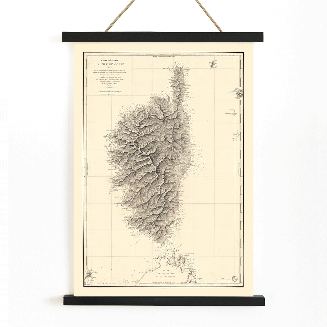
Depot General de la Marine was the official French naval institution responsible for producing precise nautical charts and coastal surveys throughout the nineteenth century. Its cartographers played a vital role in supporting maritime navigation, defense, and trade, translating scientific observations into practical tools for seafarers and the state.
Works such as this map of Corsica emerged from a period when advances in hydrography and standardized cartographic methods enabled nations to better understand and manage their maritime domains. As an official document, this map reflects the intersection of scientific rigor and state authority in the age of exploration and empire.
The Artwork
This 1831 map of Ile De Corse was created to ensure safe navigation around Corsica, a strategically significant island between France and Italy. At the time, Corsica was not only notable as Napoleon’s birthplace but also as a key point for shipping routes, naval patrols, and communications in the western Mediterranean.
Such charts were essential for captains planning approaches, identifying harbors, and understanding the island’s coastal features. Today, this map appeals to both travelers and history enthusiasts, and it complements other vintage maps as a piece that brings historical geography into contemporary interiors.
Style & Characteristics
This vintage print is characterized by its precise engraved linework, orderly labeling, and clear cartographic layout designed for practical use. The restrained palette features dark ink on softly aged, beige-toned paper, lending an archival and timeless feel.
Subtle variations in text size and careful spacing create a harmonious composition, while the overall mood is studious and quietly adventurous. Its black and white elegance aligns with selections in our black and white wall art collection, making it ideal for those seeking understated sophistication.
In Interior Design
As wall decor, this Corsica map suits a study, entryway, or living room where a touch of historical intrigue is welcome. It pairs well with minimalist interiors, classic French decor, and coastal themes, especially alongside materials like wood, linen, or stone.
The neutral ink and paper tones harmonize with warm neutrals, matte black, and brass accents. A slim black or natural oak frame enhances its architectural lines, or you can explore sea and ocean wall art to create a refined maritime display.