


You may also like
-
Observatoire populaire du Trocadéro Poster
Léon Jaubert · 1889 · Detailed celestial map poster with crisp constellation lines on deep blue ground
Poster from £9 · Framed from £16
Regular price From £6.00Regular price -
Planisphere celeste Poster
Claude-Joseph Drioux · 1886 · Detailed celestial map vintage print with twin hemispheres and delicate constellation linework
Poster from £9 · Framed from £16
Regular price From £6.00Regular price -
Southern Sky Star Poster Poster
The Institute of Leipzig · 1854 · Detailed southern sky print featuring crisp star points and fine constellation lines
Poster from £9 · Framed from £16
Regular price From £6.00Regular price -
Milky Way North Hemisphere Poster
Institute of Leipzig · 1949 · Detailed northern sky poster charting constellations across a luminous Milky Way band
Poster from £9 · Framed from £16
Regular price From £6.00Regular price


-

"Very nice Posters. The quality is amazing and we received it very quickly !"
-

"A shop to visit absolutely. Huge selection of posters. We spent more than an hour there !"
-

"Perfect to find gift. Price are very good. An they can frame and pack it on site"


About the Artist
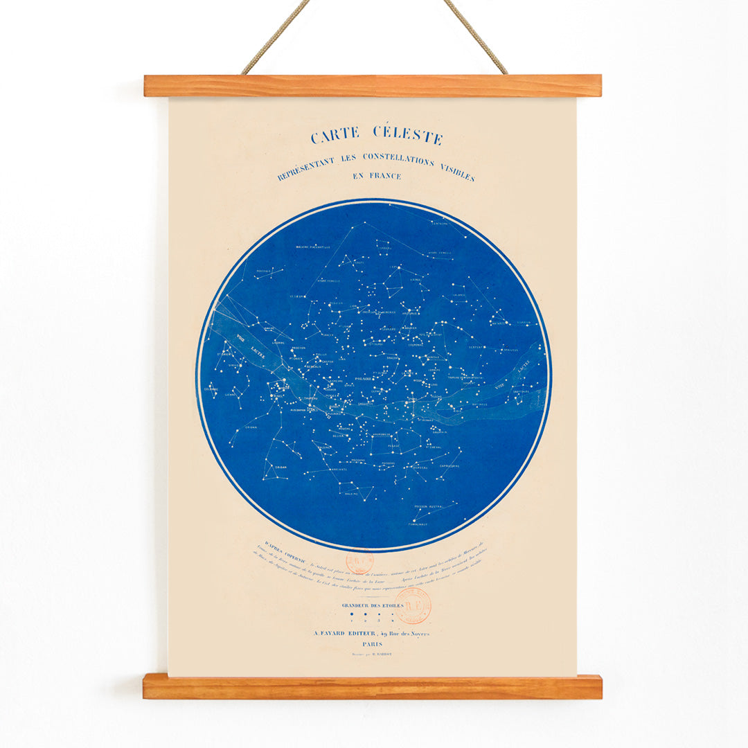
R. Barbot is credited on this celestial chart, a name associated with the flourishing world of 19th century French educational prints and scientific illustration. During this period, collaborations between astronomers, engravers, and publishers brought scientific knowledge to a broader audience, transforming complex observations into accessible and visually engaging works for schools and the public.
This chart exemplifies the era’s commitment to education and the democratization of scientific understanding. Rather than being created for private collectors, such works were intended for classrooms and libraries, serving as both instructional tools and objects of aesthetic appreciation. They reflect a time when astronomy became part of everyday culture through atlases and wall charts.
The Artwork
Carte céleste was produced at a moment when the mapping of the night sky was being standardized and widely disseminated. The chart provided viewers with a practical guide to the constellations and celestial coordinates, making the heavens more approachable and navigable. It was likely issued as a plate for reference collections and later reproduced for broader educational use, embodying the 19th century spirit of scientific curiosity and public engagement.
Today, this vintage celestial map poster preserves that sense of discovery, inviting viewers to explore the sky as both a scientific and poetic realm.
Style & Characteristics
The image features a structured astronomical layout, with dense fields of stars, precise constellation outlines, and detailed French labels. Fine linework and careful typographic hierarchy lend clarity and order to the composition, while the deep blue background evokes the night sky. Pale inks highlight the constellations and boundaries, creating a striking contrast that enhances legibility.
The softly aged margins add warmth and a sense of history, making the print feel both authoritative and inviting. This classic French constellation map art print balances scientific rigor with an atmospheric, contemplative mood.
In Interior Design
This celestial map suits studies, reading nooks, bedrooms, or hallway gallery walls, offering a quiet focal point that rewards closer inspection. It pairs well with dark woods, brass, and linen, and can also serve as a vintage accent in modern interiors.
For cohesive styling, combine it with night-sky blues and warm neutrals, or display it alongside other vintage map prints. It also complements space themed wall art and fits naturally within a collection of science illustration posters.